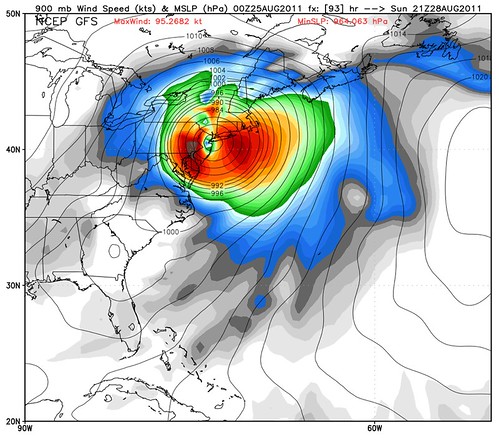
Sorry to keep posting these computer model maps, but they’re just so sensational, I can’t help myself. From the 0Z GFS:
Over on Weather Nerd, I write:
Holy hell. That map is downright terrifying. (It’s even worse when viewed as an animation. Hat tip: Ryan Maue.) It represents something pretty darn close to the true worst-case scenario, the New York nightmare that experts have feared for years — a Category 2 hurricane, perhaps even a low-end Cat. 3, making landfall in New Jersey, and pushing a severe storm surge into New York harbor, with devastating effects.
I emphasize again that this is just one possible scenario among several, and probably not even the most likely. But such scenarios are always unlikely, right up until the point when they’re about to happen — at which point it’s too late to prepare for them! So everyone needs to prepare as if they’re going to suffer a direct hit, and not just by a minimal hurricane, but by a monster. (And if that preparation proves, in retrospect, to have been unnecessary, breathe a sigh of relief and know that you were right to prepare for the worst, not blithely assume the best.) … This is no mere hypestorm.
For those who remember me from Katrina, I’ll say that the “Get the Hell Out!” moment hasn’t arrived yet. But if we get to tomorrow night and things haven’t changed in the forecast… it may.
Stay tuned to Weather Nerd and my Twitter feed for updates.


Ew.
But some of the projections have the storm hitting Maryland’s Eastern Shore and coming inland towards DC. As if the earthquake earlier this week wasn’t bad enough…
so happy to see you’re still sharing your thoughts on hurricanes. I’m in central Louisiana and i’ve been following you since Katrina. I got my first look at Irene on the morning news and it was like seeing Katrina all over again. This thing is massive! Those folks on the east coast are in my prayers.