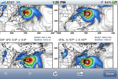
The computer models forecasting Hurricane Irene’s track have shifted back west today, decisively ending the eastward “trend” of the forecasts, and bringing New Jersey, New York City, Long Island, and Southern New England very much back into the bullseye of the risk zone. This also increases the risk of a direct hit (rather than a glancing blow) in North Carolina, and significant impacts in the mid-Atlantic region. Don’t #PANIC, but #PREPARE. This could be a big, big deal.
Details at Weather Nerd and on my Twitter feed. Below, an image of the ECMWF (European), GFDL, GFS and HWRF 96-hour forecasts, as of this afternoon:


It’s almost like (insert deity of choice) put a little English on the hurricane or something. I’m just sayin’, if that sucker direct hits _and_ New Madrid slips this weekend I’m thinking it’s a sign.
Oh no! I’d better get all my sodomy in ASAP!!
If you need a hurricane and/or earthquake to get your sodomy on then maybe it’s time to consider a partner discussion/switch…
Shhh, James ! Casey thinks that “sodomy” is a fancy word for the green practice of drying one’s laundry on an outside clothesline without using any artificial heating …
Sod me! Who brought up sodomy?