Hurricane Bill is no more, downgraded to a Tropical Storm — and simultaneously declared extratropical — at 5:00 AM EDT today, after lashing Atlantic Canada yesterday and overnight.
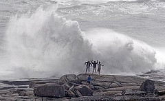
Dr. Jeff Masters has a round-up of Bill’s impacts on Nova Scotia and Newfoundland. Most notable, to me, is this tidbit: “At Peggys Cove, three men were hit by a giant wave but were not hurt. A gift shop and attached home in the village were swept off of their foundation.” Here’s are a couple of photos of the scene at Peggys Cove:
Peggys Cove is possibly my favorite place on Earth, and if Dr. Masters is talking about the gift shop I think he’s talking about, I’ve been there — I’m fairly certain I even own a lighthouse trinket from there. As for the three men, they’re very lucky they weren’t hurt. They can’t say they weren’t warned.
Back in the States, two people weren’t so lucky, including, tragically, one 7-year-old girl, who was swept out to sea from Thunder Hole by a massive wave caused by Bill’s aftereffects and the rising tide. The other victim of Bill’s waves was a 54-year old man who drowned in Florida. They are the first casualties of the 2009 Atlantic hurricane season. R.I.P.
Anyway, Bill is now just a big ol’ ocean storm, speeding away from Newfoundland at upwards of 45 mph, and heading toward Europe, where it will cause rain and wind in 2-3 days. Here’s a satellite view and a computer model plot of its possible tracks:
So ends the last of the tropical trio — Ana, Bill and Claudette — that popped up on August 15 and 16, after 2 1/2 months of inactivity. For now, the Atlantic basin is quiet again. But we have our first official “Invest” since proto-Claudette: Invest 92L, northeast of the Lesser Antilles. Dr. Masters summarizes:
A tropical wave with a moderate amount of shower activity is moving west-northwest at 20 – 25 mph and is approaching the northern Lesser Antilles Islands. This wave was designated “Invest 92” (92L) by NHC this morning. The wave is under about 20 – 30 knots of wind shear due the strong upper-level winds from the west. These winds are being created by the counter-clockwise flow of air around an upper-level cold-cored low north of Puerto Rico. This low is expected to move west-southwest and slowly weaken over the next two days, allowing shear to drop to the moderate 10 – 20 knot range beginning Tuesday night, according to the SHIPS model. By Wednesday, the upper low is predicted to be weak enough and far enough away from 92L that it will have a chance to develop. Most of the models show some degree of development of 92L by Thursday, when it is expected to be a few hundred miles off the coast of South Carolina. This wave could turn northward and give a wet weekend to New England, though it is too early to be confident of this. NHC is giving 92L a low (less than 30% chance) of developing into a tropical depression by Wednesday morning. The upper-level low will create plenty of wind shear and dump cold, dry air into 92L over the next two days, so Wednesday is probably the earliest we can expect the system to begin organizing into a tropical depression.
Eric Berger also has a round-up. He notes: “If this were college football season instead of hurricanes, we’d essentially be at the end of the non-conference schedule heading into conference play. … [H]istorically we’re just about at the point where hurricane season really heats up … Although we are rapidly approaching the peak of hurricane season, there’s surprisingly little activity in the tropics at this time.” But he then notes several potential areas of interest, and predicts we’ll have Tropical Storm Danny sometime in the next week. He adds:
So how are we doing, climatology-wise? Overall this season has been pretty average. During the typical, 10-named storm season, we’d expect to have three named storms by Aug. 20, with one becoming a hurricane, which is what we’ve had.
Through the end of August we’d expect to have an Accumulated Cyclone Energy (a statistical measurement of a season’s overall activity) value of 33.4, and right now we’re at about 27.0. So we’re just slightly below normal with a week to go in August.


