![]() Danny weakens, is not likely to become a hurricane, says Dr. Jeff Masters; Invest 94L forms off African coast
Danny weakens, is not likely to become a hurricane, says Dr. Jeff Masters; Invest 94L forms off African coast
Twitter: Newly discovered fact: …
Every rock in Ireland
Continuing on the theme of photos from my parents’ visit to Denver (which has been great fun!), here are some from our lunch date Tuesday at Katie Mullen’s, a neat Irish restaurant and pub downtown that opened in February.
I love this shot of my Dad, wearing his classic skeptical-Joe-Loy face:
Here’s my Mom taking a picture of him, with her Guinness in the foreground:
Exodus
Fans leave Coors Field last night after the Dodgers’ 6-1 win over the Rockies ended Colorado’s four-game winning streak:
I took the photo from Fadó Irish Pub, where I was watching Brian Clancy (here’s a photo) with my Mom, my Dad, Kristy and her boyfriend, and maybe a hundred of our closest Rockies-fan friends, who dropped in on their way home from the game. Talk about a great location on a game night! Anyway…
Oh, and here’s a shot I took earlier, on our way to Fadó, of Denver’s Union Station:
P.S. Here are Kristy and my Mom doing the “green alligators and long-necked geese” dance, as Brian Clancy sings “The Unicorn”:
Heh. “BEERS,” indeed.
FriendFeed: DNA swap could …
FriendFeed: T.S. Danny not …
Doublethink 101
Thought for the day: It just occurred to me that there’s a noticeable theme, cutting across various issues, to a number of the arguments I’ve been reading and hearing lately from many Republicans and conservatives. That theme is cognitive dissonance. For instance:
• Obama’s soft-on-terror stances are endangering America by dismantling crucial Bush policies. This proves the Republicans were right about him. Also, Obama’s “hope and change” mantra was a fraud, because he’s keeping many Bush policies in place. “Meet the new boss, same as the old boss.” This proves the Republicans were right about him.
• It’s terrible that the media keeps dragging Sarah Palin’s young children into the political arena. Family should off-limits. Also, it’s terrible that Obama is telling the media not to stalk his young children on Martha’s Vineyard. Such a presumptuous demand would only be made by someone who thinks knows he’s got the media in the tank. The media sux!
• We must cut the deficit! We must stop profligate spending! We must not expand government! Also, don’t you dare make any cuts to Medicare! And if you even try to reduce spending, that automatically means you’ll “ration” care. DEATH PANELS!!!
(As best as I can tell, that last one is actually the core conservative argument against ObamaCare. It could perhaps be summarized as: “Keep your big-government paws off my Medicare, you free-spending, cost-cutting, deficit-enlarging, grandma-killing, socialist bastards.” WHAT?!?)
Not that Democrats and liberals aren’t also prone to make disingenuous, inconsistent or hypocritical arguments, mind you… but this phenomenon has been pretty egregious on the Right lately, methinks. (And, crucially, media bias notwithstanding, conservatives seem to be better at getting people not to notice when they’re engaging in blatant doublethink and doubletalk.)
FriendFeed: Adventures in (not) …
![]() Adventures in (not) proofreading: “Lt. Gov. Mark Sanford announced today he is asking Gov. Mark Sanford to resign.” Heh. http://bit.ly/lRNpR http://bit.ly/vQ179 @michellemalkin @GreenvilleNews
Adventures in (not) proofreading: “Lt. Gov. Mark Sanford announced today he is asking Gov. Mark Sanford to resign.” Heh. http://bit.ly/lRNpR http://bit.ly/vQ179 @michellemalkin @GreenvilleNews
Twitter: Top Google searches …
![]() Top Google searches right now: 1. mary jo kopechne 3. chappaquiddick 6. chappaquiddick incident 8. chapaquitic http://bit.ly/aoayI
Top Google searches right now: 1. mary jo kopechne 3. chappaquiddick 6. chappaquiddick incident 8. chapaquitic http://bit.ly/aoayI
Danny forms, may “parallel” East Coast, but likely not a serious threat

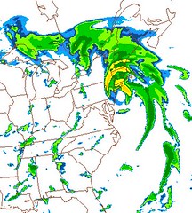
Above: Via NWS, a computer-simulated radar image for Saturday at 8:00 PM EDT. CAVEAT #1: This is a long-range, 84-hour forecast from a single computer model, and is quite likely to be wrong. CAVEAT #2: It also doesn’t look much like a hurricane. A commenter on Alan Sullivan’s blog mocks it as “Occluded Front Danny.” Heh.
Tropical Storm Danny has formed east of the Bahamas, with top sustained winds of 45 mph. Slow strengthening is expected, and Danny is likely to be a hurricane by Friday. Everyone from the Carolinas northward to New England and Atlantic Canada is at risk for a possibly landfall from this storm — though Danny could well remain offshore of the U.S. entirely, and is unlikely, in any event, to become a major hurricane.
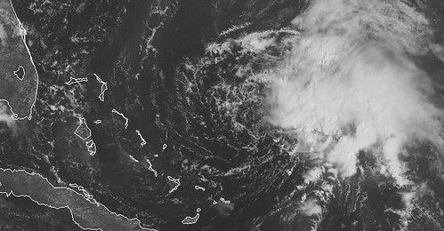
As you can see on the visible satellite view above, Danny is a rather asymmetrical storm right now, with the center of circulation located inside the swirl of low clouds near the center of the image, while all the heavy rain and wind is east of the center. This is due to the influence of an upper-level low pressure system that’s shearing off all the high clouds on the storm’s west side. The NHC’s initial discussion notes:
THE STRUCTURE AS MUCH RESEMBLES A SUBTROPICAL CYCLONE AS A TROPICAL CYCLONE. HOWEVER…CYCLONE PHASE ANALYSES FROM FLORIDA STATE UNIVERSITY SUGGEST THAT DANNY IS MARGINALLY MORE TROPICAL THAN SUBTROPICAL…HENCE THE DESIGNATION OF TROPICAL STORM.
The discussion adds that upper-level lows on either side of Danny create an environment that is not “ideal…for strengthening.” The environment is expected to become more favorable in 24-36 hours, then less favorable again after 48 hours, as a big trough starts to recurve the storm. So Danny will have a narrow window for any significant strengthening, and is unlikely to ever undergo truly rapid intensification. Hence, intensification to anything greater than perhaps a high Cat. 1 or low Cat. 2 seems unlikely. Alan Sullivan predicts: “This system is highly asymmetrical and will probably remain so throughout its lifespan. Convection will remain displaced from the center of circulation.”
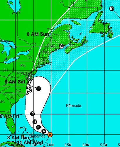
That potential asymmetry is significant, in light of Danny’s projected path:
Sullivan writes that, because the rain and wind is entirely east of the center of circulation, “it is possible that [Danny] will pass very close to some parts of the East Coast in a few days without any notable weather ashore. All the storminess will stay at sea unless the center of the system moves bodily inland. That is very unlikely. So ignore the media. This is no big deal at all.”
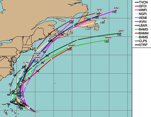
We shall see. It is entirely possible Danny won’t even get that close — the NHC acknowledges that its forecast track is “a little to the left of the model consensus.” The models generally keep Danny away from the coast:
The NHC notes, however, that “THE FORECAST TRACK IS ROUGHLY PARALLEL TO THE U. S. EAST COAST…AND ANY DEVIATION FROM THE TRACK COULD MAKE A LARGE DIFFERENCE IN WHAT AREAS GET IMPACTED BY DANNY. THEREFORE…IT IS IMPORTANT NOT TO FOCUS TOO MUCH ON THE EXACT FORECAST TRACK.”
As things stand, some folks are comparing Danny to 1993’s Hurricane Emily, which teased the East Coast for days without ever making landfall, while others are drawing comparisons to 1991’s Hurricane Bob, which whacked Southern New England as a Category 2.
My gut tells me Sullivan is right, and Danny won’t be a big deal, but again, we shall see.
UPDATE: Sullivan has a new post up, in which he describes Danny’s naming as a “marginal call” and writes:
Some models provide better conditions for development in 36 hours and make Danny a minimal hurricane near Cape Hatteras. But I expect the asymmetry to remain. Danny’s strong weather will be well east of the center. It poses no threat to NYC, which is within the cone for potential passage of the storm center, should it track to the left of model consensus. If Danny’s center came ashore in NYC, tropical storm conditions would occur on the south shore of eastern Long Island, and on Cape Cod — not in NYC. With an asymmetrical storm, the track of the center is not relevant; the track of the convection is the important thing. So there is nothing to worry about, NYC. Don’t let the media spook you.
If New Yorkers (and the media) have become sufficiently aware of the grave threat a worst-case scenario hurricane would pose to NYC that citizens can be effectively “spooked” about it, that’s a positive development. A few years ago, it seemed like the possibility (indeed, eventual inevitability) of a catastrophic New York landfall was something only weather nerds and disaster buffs knew about. Increased awareness is good. Now, let’s not blow it with a bunch of overly sensationalized “false alarms” from storms that pose no real risk. Danny is very, very unlikely to be the Big One.
UPDATE 2: In comments, Sullivan adds: “Someday, maybe next year, or decades from now, there will be a real cyclone up from the deep tropics while an inland US trough goes negative tilt. That future hurricane will hit NYC like a bolt from a slingshot, but there will have been so many false alarms that people won’t take it seriously until too late.”
Meanwhile, Capital Weather writes:
At this time, Danny’s circulation is associated with an upper-level cyclone, and very likely has many attributes similar to that of a midlatitude system (e.g., a Nor’easter). This setup is typically hostile to tropical development. In particular, the dry, non-tropical air on its periphery…and the strong wind shear (winds that change direction and/or speed with height and tend to rip storms apart or prevent them from getting stronger) near the edges of the circulation tell me that it has yet to acquire truly tropical characteristics.
The nearly comma-shaped asymmetry in the cloud pattern tells us that the ingredients for significant intensification are not yet in place. Most of the thunderstorm activity is displaced well to the east of the center of the low-level swirl, typical of a highly sheared circulation. … Even in the event the center makes a close approach to the coast, the worst weather should be displaced east of the center’s track and remain offshore.


